
On this day in WNC history: Meeting in Fayetteville, the North Carolina General Assembly passed a new law in 1787 transferring a chunk of land from Burke to Rutherford County.
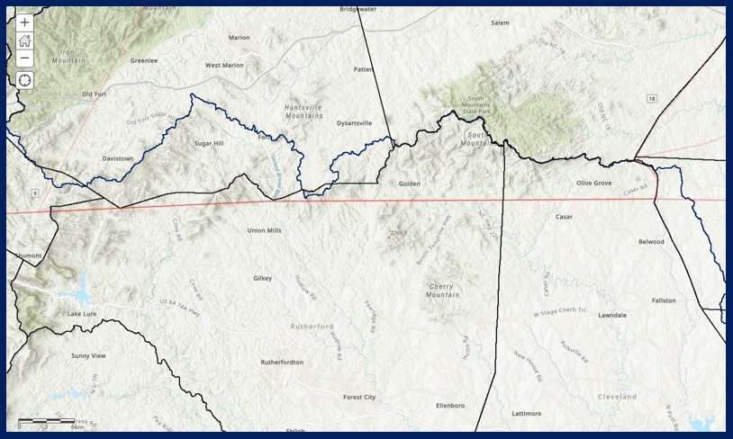
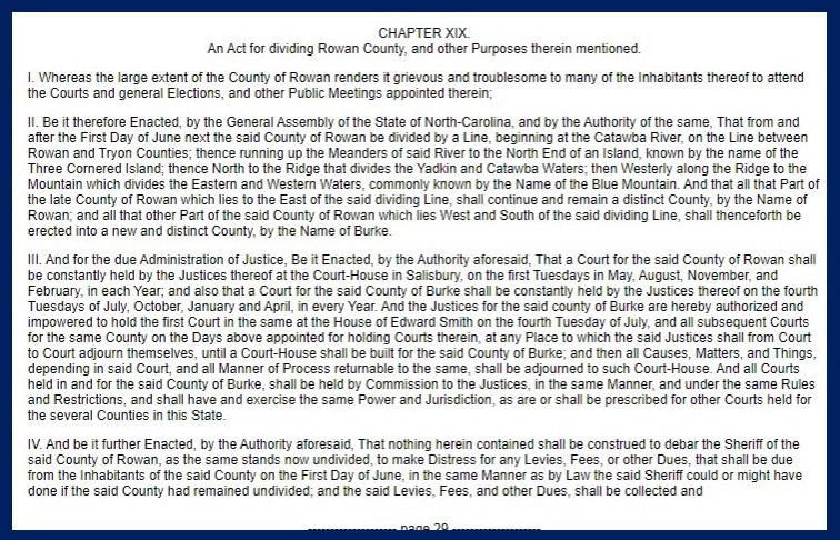
North Carolina’s western county boundaries created during the colonial era often imposed straight lines onto a region that was anything but flat and regular. The Revolutionary government created Burke County in 1777 from the westernmost portion of the massive Rowan County, using the straight line of latitude that ran west into the mountains, separating Burke from Rutherford County to the south. While Burke was created because of the difficulty of the westernmost residents of Rowan County to attend business and government functions in the county seat, the new boundaries still proved troublesome for some inhabitants in the South Mountains. This same area also proved difficult and strategically important during the American Revolution. Patrick Ferguson’s Loyalist forces fought a small skirmish near the head of Cane Creek in 1780 at a gap locals believed was impassible for his army.
The 1787 law noted: “Whereas by reason of a ledge of mountains that divide the waters of the first Little Broad [R]iver from the waters of Silver and Cain creeks, it is extremely difficult for the inhabitants on the south side of the said ledge to attend the court house of the county of Burke…” The assembly’s compromise accounted for the natural features of the land, annexing the northernmost portion of the Broad River watershed and its residents into Rutherford County. A look at the modern county boundaries of WNC reveals that many borders have been created or adjusted to follow ridges and watersheds — reminders of the ways in which our relationship with the environment of the WNC mountains has shaped the region’s history.
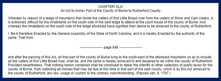
“An Act to Annex Part of the County of Burke to Rutherford County,” NC Colonial and State Records, V24
“An Act for Dividing Rowan County, and Other Purposes Therein Mentioned,” NC Colonial and State Records, V24
Map of watersheds (blue lines), modern county boundaries (black lines), and 1780s county boundaries (red lines), created by WNCHA)